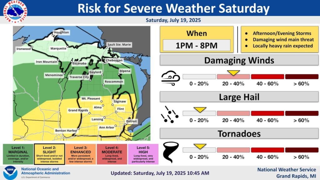
UPDATE: Severe storms are rapidly approaching Michigan, bringing potential wind gusts of up to 60 mph this afternoon. Weather systems are currently moving across the northern tip of the Lower Peninsula and into the eastern Upper Peninsula, with another severe weather front advancing over Lake Michigan toward West Michigan.
According to the National Weather Service (NWS), wind damage is the primary concern as these storms develop. The NWS urges residents to stay alert as severe weather could manifest between 1 PM and 8 PM today. “A threat for severe weather exists today,” stated NWS meteorologists in Grand Rapids. “We expect storms to develop over Lake Michigan in the midday hours, moving into Western Lower Michigan early this afternoon.”
As the afternoon unfolds, the potential for thunderstorms and hail is being monitored closely. While some areas may only experience brief showers, others could face heavy rainfall leading to localized flooding. The NWS warns that the anticipated storms could form a severe line moving from west to east, posing risks of damaging winds.
Residents are advised to prepare for possible wind gusts reaching between 50 to 60 mph, which could result in downed trees and power outages. Additionally, localized heavy rain may contribute to short-term flooding in low-lying areas.
For the most current updates, check the live radar on the MLive weather page. Stay tuned as the situation develops, and prioritize safety by securing outdoor items and monitoring local alerts.
As storms gather strength over Lake Michigan, the urgency of this forecast cannot be overstated. Prepare now to minimize risks and stay informed through official channels.