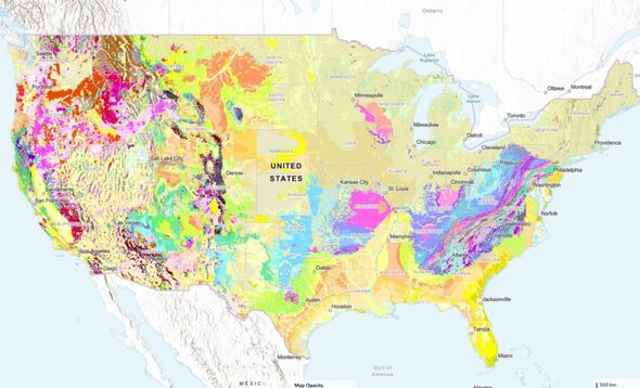
A groundbreaking new interactive map released by the U.S. Geological Survey (USGS) offers users an unprecedented view of the geological features beneath their feet. Unveiled in August 2023, this detailed map is the culmination of three years of extensive research and builds upon decades of previous mapping efforts. It enables users to explore the ages and types of rocks and sediments located at and below the Earth’s surface.
The innovative tool organizes geological units by shared characteristics such as composition and age. Users can search for specific geological properties or click on various sections of the map for detailed information and links to additional resources. “This map provides complete, analysis-ready geologic data for the nation, in a format that is easy to expand going forward,” stated Joseph Colgan, a research geologist at USGS and leader of the project team. He emphasized that the map aims to enhance educational engagement and foster a greater public appreciation of geology.
Faster Mapping Through Automation
A significant advancement in this project was the development of an automated solution that efficiently combines existing geological maps from state geological surveys and USGS. This method allowed researchers to assemble the map in a fraction of the time typically required for such a large-scale project. According to Sam Johnstone, a USGS research geologist and lead developer for the mapping initiative, “Ongoing mapping efforts continually make new discoveries, but past national maps took decades to create, while our new method allows us to update our national map faster than ever possible before.”
This map is part of a broader initiative by the Association of American State Geologists and the National Geologic Map Database to standardize geological maps across the United States. The USGS encourages a wide range of users, from casual enthusiasts to professionals in the field, to engage with the map and learn more about the geological landscape of their regions.
Potential Applications and Future Developments
Experts have highlighted numerous potential applications for the new map, including its use in identifying energy, mineral, and water resources. “Geologic maps have many uses, such as helping experts assess earthquake risks, inform land use decisions, and guide community planning and real estate insurance,” noted Christopher Swezey, the USGS National Cooperative Geologic Mapping Program coordinator.
Despite its advancements, the map remains a work in progress. Variations in how geological data are collected and published can lead to discrepancies, particularly evident along the Idaho-Washington border, where each state provided different information about the rock layers in that area. “Such disparities are unavoidable on the new map,” Johnstone explained. “The goal was to integrate data without altering the original maps’ interpretations. These disparities also highlight opportunities for future collaboration among state agencies and USGS.”
As the mapping project evolves, researchers anticipate ongoing improvements and refinements. The USGS’s commitment to making this data publicly accessible could significantly enhance the understanding of geology and its implications for various sectors, from environmental management to urban planning. By bridging gaps in geological knowledge, this new interactive map is poised to transform how we perceive and interact with the Earth beneath us.