PASADENA, CA – A groundbreaking image captured by NASA’s Mars Odyssey orbiter reveals Arsia Mons, one of the tallest volcanoes in the solar system, silhouetted against Martian clouds, offering an Earth-like scene on the Red Planet.
Breaking: Unveiling a Martian Giant
Just before dawn on May 2, a camera 240 million kilometers from Earth captured a moment that seemed almost terrestrial: clouds hugging the flanks of a towering mountain, with its summit rising defiantly above. However, this scene unfolded on Mars, not Earth. The mountain in question is Arsia Mons, seen from orbit around the Red Planet.
The image, captured by NASA’s Mars Odyssey orbiter, is the first of its kind: a volcano on Mars seen on the horizon, towering above a sea of early-morning water ice clouds. It’s the Martian equivalent of watching Everest rise through Himalayan fog, but on a planetary scale that dwarfs even Earth’s greatest peaks.
“We picked Arsia Mons hoping we would see the summit poke above the early morning clouds,” said Jonathon Hill of Arizona State University, who leads operations for the orbiter’s camera. “And it didn’t disappoint.”
Immediate Impact of the Discovery
NASA’s 2001 Mars Odyssey orbiter captured the photo of Arsia Mons, an ancient Martian volcano, while the spacecraft was studying the Red Planet’s atmosphere, which appears here as a greenish haze. This unique vantage point offers new insights into Mars’ atmospheric conditions.
Sunrise on a Distant World
Arsia Mons stands nearly 20 kilometers tall—more than twice the height of Mauna Loa, Earth’s largest volcano from seafloor to summit. It sits in Mars’ Tharsis region, a vast volcanic plateau that also houses Olympus Mons, the tallest volcano in the solar system. Together with Pavonis Mons and Ascraeus Mons, Arsia Mons forms a chain of giant volcanoes aligned along a planetary crack in the crust.
What makes this image so striking is its vantage point. Rather than gazing down from above, Odyssey rotated 90 degrees in orbit to look toward the Martian limb—the edge of the planet’s disk. It’s a move the orbiter only began performing in 2023, despite having been in space since 2001.
This particular view shows Arsia Mons silhouetted against a haze of greenish clouds—water ice, not carbon dioxide—at a time when Mars was at its farthest point from the Sun, a phase called aphelion.
Key Details Emerge
During aphelion, colder temperatures cause a wide belt of clouds to swirl around the equator. This aphelion cloud belt is a well-known Martian feature, but until now, scientists had never seen a mountain summit rising through it from this angle.
“We’re seeing some really significant seasonal differences in these horizon images,” said Michael D. Smith, a planetary scientist at NASA’s Goddard Space Flight Center. “It’s giving us new clues to how Mars’ atmosphere evolves over time.”
By the Numbers
This phenomenon is scientifically useful. Water ice clouds form when cold air is forced up the slopes of the volcano, expands, and cools. The clouds thicken during aphelion, revealing how Mars’ atmosphere interacts with its geography.
Eyes on the Red Planet’s Shifting Skies
Mars Odyssey has been quietly working for nearly a quarter-century, making it the longest-operating mission around another planet. Originally launched to map the chemical elements and minerals on Mars, it has since evolved into an atmospheric observer, geologist, and now—thanks to its THEMIS camera—a cosmic photographer.
THEMIS, short for Thermal Emission Imaging System, captures both visible and infrared light. Its infrared capabilities help scientists locate subsurface water ice—crucial information for future crewed missions, as that ice could provide water, oxygen, and even fuel.
Background Context
In addition to its atmospheric studies, Odyssey’s camera can image Mars’ tiny moons Phobos and Deimos, and observe seasonal changes in dust and cloud formation. This particular image of Arsia Mons is the fourth such “limb” observation the spacecraft has made.
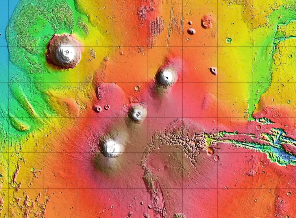
Arsia Mons is the southernmost of the three volcanoes that make up Tharsis Montes, shown in the center of this cropped topographic map of Mars. Olympus Mons, the solar system’s largest volcano, is at upper left.
Expert Analysis and Future Implications
ESA’s Mars Express mission, which also studies the region, has revealed dramatic collapse zones on Arsia Mons’ flanks. These pits, some up to 2 kilometers deep, formed as lava drained from chambers beneath the volcano. Once hollowed out, these chambers collapsed under the weight of surface rock, leaving behind jagged scars.
For scientists and engineers planning the next generation of Mars missions, these images are more than just pretty pictures. Understanding the planet’s weather, cloud formation, and seasonal variation can directly influence where and when we land future rovers—or people.
As NASA continues to explore the Red Planet, the insights gained from these images will play a crucial role in shaping the future of Martian exploration.