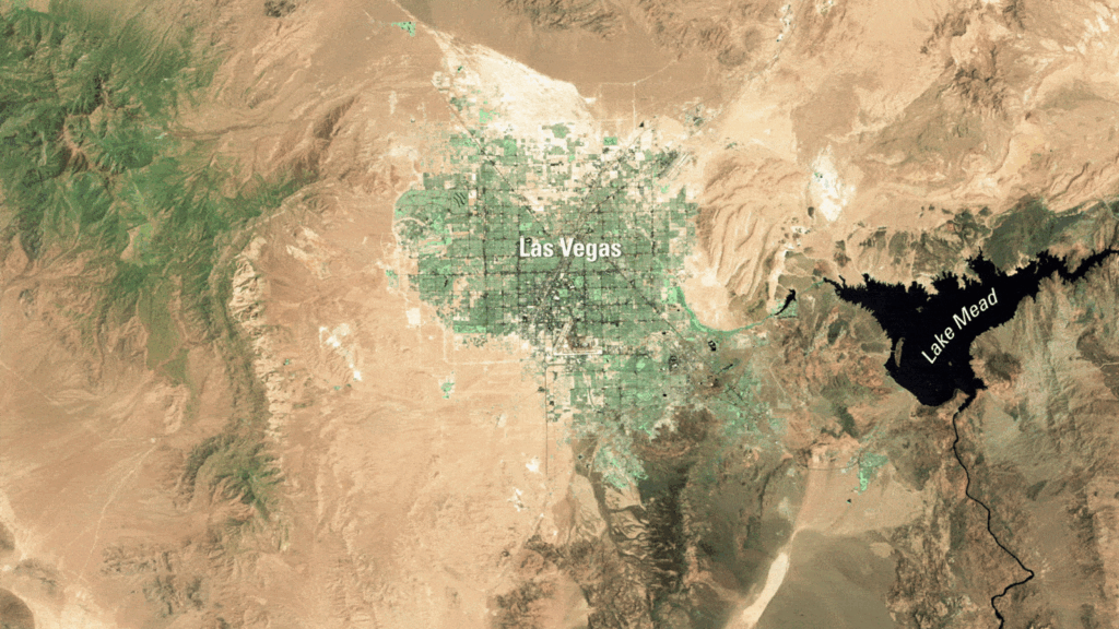
LAS VEGAS, Nevada – The final image captured by the iconic Landsat 7 satellite reveals a striking transformation of Las Vegas over the past 25 years, showcasing the city’s dramatic growth in the heart of the Mojave Desert.
Immediate Impact
The Landsat 7 satellite, co-owned by NASA and the U.S. Geological Survey (USGS), has concluded its mission with a poignant final image taken on May 28, 2024. This image mirrors one of its first photographs from July 4, 1999, highlighting how Las Vegas has nearly doubled in size during the satellite’s operational lifespan.
Key Details Emerge
Launched on April 15, 1999, Landsat 7 has been a vital tool in Earth observation, capturing over 3.3 million images of the planet’s surface. The satellite orbited Earth approximately every 99 minutes, providing invaluable data for mapping and environmental monitoring.
Quick Facts:
- Location: Las Vegas, Nevada [36.10457930, -115.1448612]
- Photos Taken: July 4, 1999, and May 28, 2024
- Satellite: Landsat 7
By the Numbers
Between 2000 and 2023, the Las Vegas metropolitan area’s population surged from 1.38 million to 2.33 million, marking an increase of approximately 69%. By 2025, the population is projected to reach 2.4 million.
Background Context
The Landsat program has been capturing images of Earth’s surface since 1972, with Landsat 7 representing a significant upgrade in its ability to photograph urban areas. The satellite has played a crucial role in the development of mapping services like Google Maps and has documented key historical events, including the 9/11 attacks and Hurricane Katrina.
Expert Analysis
According to a statement from the USGS, Landsat 7 will now drift in space for approximately 55 years before reentering and burning up in the atmosphere. Experts emphasize the satellite’s contribution to understanding urban expansion and environmental changes.
Regional Implications
The satellite images also reveal changes in Lake Mead, an artificial reservoir of the Colorado River. The lake appears smaller in the latest images, potentially due to increased water consumption and climate change effects. However, NASA’s Earth Observatory notes that the lake’s size naturally fluctuates, complicating assessments of anthropogenic impact.
What Comes Next
With Landsat 7 now decommissioned, the focus shifts to its successors. Landsat 8 and Landsat 9 continue to provide critical data, ensuring the legacy of the Landsat program endures. These satellites will carry forward the mission of monitoring Earth’s changing landscapes and informing future urban planning and environmental strategies.
The conclusion of Landsat 7’s mission marks the end of an era, but the insights gained will continue to shape our understanding of Earth’s dynamic environments and the challenges of sustainable development.