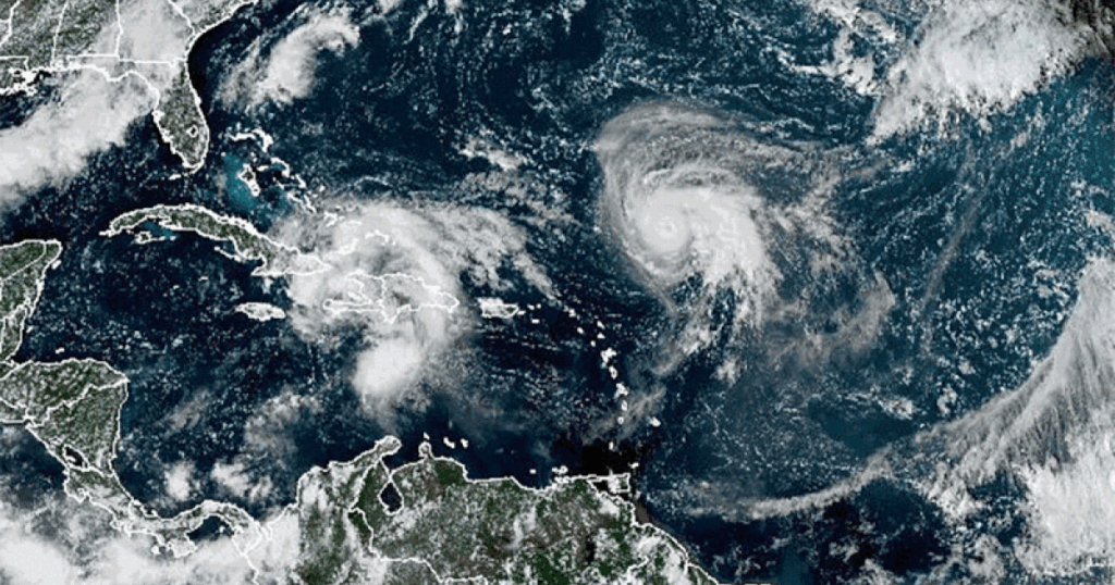
Hurricane Humberto has intensified to a Category 4 storm, with maximum sustained winds reaching 145 mph as of September 15, 2023, according to the National Hurricane Center. Despite this significant strengthening, the storm is forecasted to remain offshore and away from the U.S. East Coast.
The hurricane is one of two active weather systems currently being monitored in the Atlantic. Humberto is expected to follow a northwest trajectory, ultimately veering north and northeast, passing between the U.S. East Coast and Bermuda. As of late Friday, there were no coastal watches or warnings issued for the affected areas.
Potential Tropical Cyclone 9 Gains Attention
In addition to Humberto, a second weather disturbance known as Potential Tropical Cyclone 9 is forecasted to strengthen into a tropical storm. This system was located northwest of Cuba on Friday night and is projected to reach tropical storm status over the weekend.
The National Hurricane Center indicated that when the system approaches the southeast U.S. coast early next week, it could attain hurricane intensity, posing risks of storm surge and high winds. A tropical storm warning is currently in effect for the Central Bahamas, while a tropical storm watch has been issued for parts of the northwest Bahamas. As of last night, this system had maximum sustained winds of 35 mph, characteristic of a tropical storm, which has sustained winds ranging from 39 to 73 mph.
Forecasts suggest that this disturbance could deliver significant rainfall, with predictions of up to one foot for eastern Cuba and between four to eight inches for the Bahamas. The storm is expected to move northward along Florida’s Atlantic coast and towards South Carolina by Monday and Tuesday.
Uncertain Future for Potential Tropical Cyclone 9
While the trajectory for the upcoming days appears somewhat clear, the National Hurricane Center cautioned that there is considerable uncertainty regarding the system’s path beyond the initial three-day forecast. It is anticipated that the storm may slow significantly and potentially stall near the South Carolina coast.
As the situation develops, residents in vulnerable areas should remain vigilant and stay informed through official channels. The impact of these storms underscores the importance of preparedness in the face of unpredictable weather patterns.